Tuesday, August 4, 2009
Tuesday, July 28, 2009
Tuesday, July 21, 2009
Image Rectification
Image rectification is very useful because it allows the viewer to see actual structures and the lay of the land that is geographically accurate. A great example of this is when the landscape has been changed due to an extreme disaster and first responders need accurate maps to be used from the ground. As useful as image rectification is, there are pitfalls. If the image is out of date and the landscape has changed considerably, it could actually become an impedance. The same applies to images that have been rectified poorly.
Wednesday, July 15, 2009
Module 2 Lab
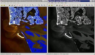
Roads: have absorbed more heat and remain warmer through the night
Natural and man-made vegetation: did not retain heat though the night
Sidewalks and patios: have absorbed more heat and remain warmer through the night
Storage sheds in back yards: no internal heat source and heat from sun was not retained overnight
Automobiles: cars that have not been running recently appear dark, cars that have been running recently show hot spots on the engines
Bright spots on many of the roof tops: heat from chimneys or roof vents
Wednesday, July 8, 2009
Wednesday, July 1, 2009
Problems with the Orthophoto
A couple of the problems I inferred from the photo were:
1. It was difficult to determine what the buildings were used for.
2. I did not know the time and date of the photo, so it may make types of vegetation hard to identify.
1. It was difficult to determine what the buildings were used for.
2. I did not know the time and date of the photo, so it may make types of vegetation hard to identify.
Friday, May 1, 2009
Great Lakes Wind Farm - Zoomed
Great Lakes Wind Farm

I chose an offshore location because it had the greatest wind speed and minimized any negative impacts. An offshore location does bring up new environmental concerns, but according to the AWEA (http://www.awea.org/faq/wwt_offshore.html), offshore wind farms have minimal impact on sea life, coastal erosion, and fishing.
Sunday, April 26, 2009
Sunday, April 19, 2009
Tuesday, April 14, 2009
Tuesday, April 7, 2009
Thursday, April 2, 2009
Sunday, March 22, 2009
Sunday, March 8, 2009
Sunday, February 22, 2009
Thursday, January 22, 2009
Good Map
Bad Map
This is a example of a bad map. There would be no way to find Minnoz Restaurant & Lounge using this map alone.
Mental Mapping Exercise
Subscribe to:
Comments (Atom)


